MapGage
- 4 min to read

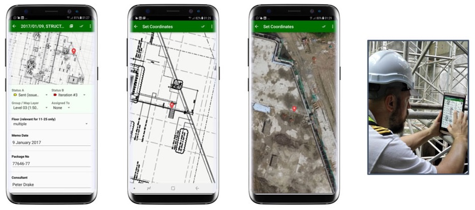
About the city. Before using MapGage, Rotterdam printed city drawings and recorded the observed discrepancies on the drawings. When they returned to the office, it took them a lot of information, photos, and time to interpret this information so that it could be updated into their CAD drawings.
Goal
The aim of the project is to provide city administrators with instructions and procedures related to the installation, calibration, monitoring, inspection, and maintenance of smart city IoT sensors.
Implementation period. The project launched in 2018.
Fact
The accuracy and reliability of sensor data is difficult to establish. The correct installation and calibration of IoT smart city sensors must be guaranteed.
Solutions
MapGage is a startup that was part of the Rotterdam cohort of the PortXL acceleration program in 2018.
MapGage is:
- Mobile GIS application using multiple layering for a geographical base-map, layering of various GIS data sources is carried out using various types of orthophoto mosaic maps (RGB, thermal, NVDI…)
- CAD and drawings are integrated into layers on top of map backgrounds and images.
- Various forms and procedures can be created by the customer on the Internet platform and immediately available in the mobile app.
- GIS data in the mobile app is available and can be edited online or offline, synchronization is performed immediately after network recovery.
- Additional custom improvements can be developed to meet specific needs, achieving a high level of customization.
Team
MapGage, Municipality of Rotterdam.
Timeline
- During the implementation period, it became clear that the MapGage solution not only takes over the existing procedure but also expands the collected information with images, material details (there are no restrictions on the number of data sets that can be created) and allows to generate content for cross-industry exchange.
- Time savings were calculated at the level of 50% of the costs of field operators for administrative and reporting tasks that follow the fieldwork.


If you notice an error or inaccuracy in our editorials, please email [email protected] so we can look into it.