Wien gibt Raum (Vienna gives space)
- 13 min to read

Vienna, Austria
About Vienna. Urban public space is like a modern city’s calling card. Locals spend a significant part of their daily lives in public areas, and for visitors, public space makes up a major share of the city’s special flair and ambience.
Goal
The program aims to reorganize the distribution of tasks and responsibilities for official permits and the management of objects and activities in public spaces. Internal administration processes are restructured; at the same time, users are provided with a new customer interface in the form of a (digital or physical) one-stop-shop, which is based on customized software solutions.
Additional goals:
- “Wien gibt Raum” will make proceedings for the use of public space easier and faster. Soon you will be able to submit your application online in a digital “One-Stop-Shop”. There you will find all information on the use of public space online. A digital assistant will guide you through the process and answer your questions. You will have only one interface to the city administration and receive all permits and transparent information about fees from a single source.
- Public space is valuable and belongs to us all. The City of Vienna enables citizens through “Wien gibt Raum” to make their ideas for public space come true. From street festivals, Grätzloasen (neighbourhood oasis) or parklets to art performances – we make the necessary steps to use public space as room for your idea as easy as possible. Moreover, the city administration surveys public space and thus gets a better overview. So public space can be decluttered, creating space for new ideas and making your neighbourhood more beautiful.
- By applying “Wien gibt Raum” the City of Vienna is using tax money responsibly. The image data created by the program can replace some of the on-site inspections or expert opinions required for future administrative processes, thus saving both time and expenses. A modern software using this data facilitates effective networking between City Administration departments. The use of public space should be fair – citizens and enterprises that play by the rules must not be put at a disadvantage. Therefore we also detect who is using public space without contributing.
Implementation period. The program Wien gibt Raum is scheduled for five years, 2017 to 2022, and combines several projects focusing on different organizational or technological aspects of public space management.
Fact
The project is so far unique in Europe and combines image data, geodata, software, and web solutions.
Solutions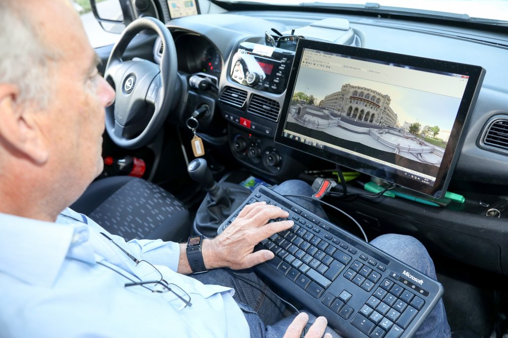
The “Vienna gives space” program simplifies the use of public space for citizens and companies. Using software, geographic information, image data of the current status from the traffic, and data on existing permits and applications are brought together. This enables the municipal departments involved to network better. The advantage for citizens and companies is that they receive a central contact point for their concerns and all permits from a single source via a digital “one-stop-shop”.
- Citizens benefit from “Vienna gives space” because ideas and initiatives are easier to implement in public spaces.
- Companies benefit from “Vienna gives space” because they can obtain permits for the use of public space more quickly and easily.
“Vienna gives space” organizes responsibility for the approval and administration of objects and activities in public space. Furthermore, the legal requirements for such permits are evaluated and modernized if necessary. The basis for many steps of the program is a technical recording of the existing objects in public space by driving them through.

Geodata, surveying data, and image data of the status quo, as well as data on permits granted and applications submitted, are integrated in a single database to facilitate effective networking between City Administration departments. The local population and business community benefit from the program by getting a single contact – a digital or physical one-stop-shop – for all inquiries and applications regarding public space to a single. At the same time, the database provides a reliable, comprehensive overview of all objects and structures present in the city’s public space, making it easier for the City of Vienna to manage public space as a whole. This also provides the basis for “decluttering” urban public space, i.e. removing illegal structures and objects, thus making more room for all user groups in the city and guaranteeing fair use of public space for everyone. So far Vienna has been the only European city to adopt this novel and comprehensive approach.
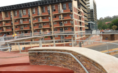
Mapping the city
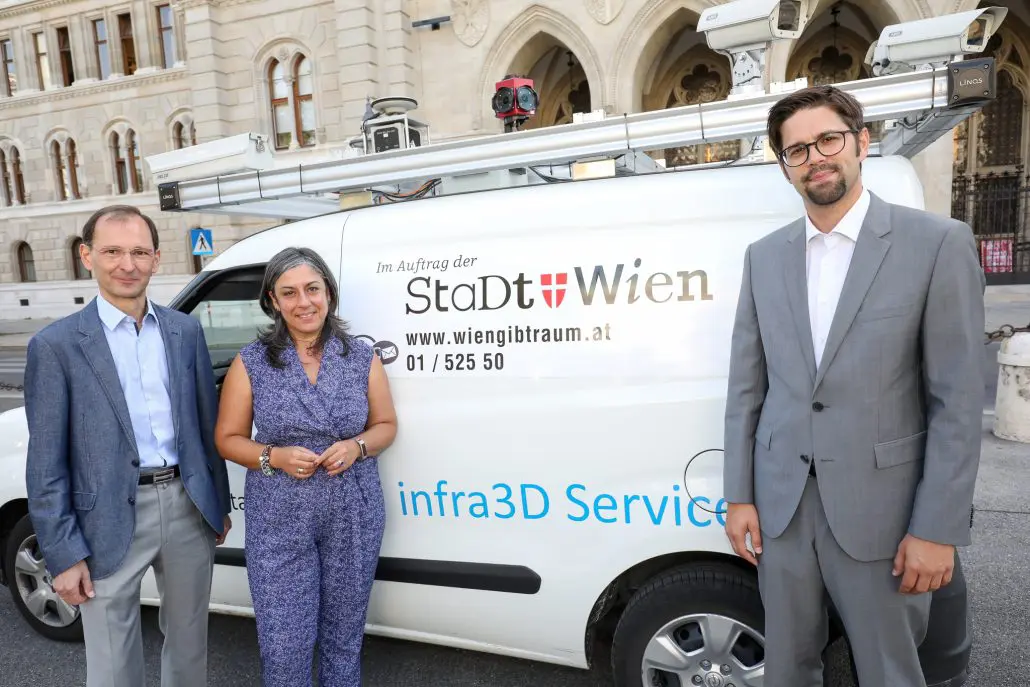
The basis for many steps taken for Wien gibt Raum is provided by comprehensive surveying of all objects and structures currently found in public areas. More specifically, mobile mapping is used to document the city’s actual status quo at a given point in time. This task is implemented by Municipal Department 41 (MA 41 – Surveyors), which serves as an internal provider of geodata for the City of Vienna. The MA 41 mobile mapping campaign employs modern imaging technologies to produce a detailed image of the city, which is subsequently used to extract the three-dimensional features of public space in Vienna. In the future, the City Administration will have access to a systematic catalogue of all objects and structures in public space, including image data and specific GIS layers for different categories of urban furniture. The GIS layers are a prerequisite for visualizing the data (i.e. inventory data and information on official permits granted) in jointly used ICT systems and for administrative monitoring processes. The image data obtained by mobile mapping are made available to the departments of the Vienna City Administration in the form of an easy-to-use, web-based image data service. The new solution can replace some of the on-site inspections or expert opinions required for future administrative processes, thus saving both time and expenses.
Technology
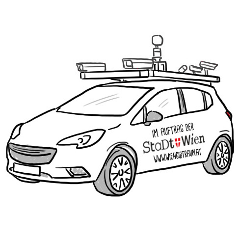
The basis for many steps taken for Wien gibt Raum is provided by comprehensive surveying of all objects and structures currently found in public areas. Modern mobile mapping technology is used to document the city’s actual status quo at a given point in time. The system uses highly precise sensors: GPS positioning and angle sensors detect the direction and position of the vehicle up to 200 times per second. A precisely calibrated camera system takes pictures with geodetic accuracy. The data is acquired while driving at normal speed. Every three metres image data is recorded by all cameras simultaneously.
The outcome is panorama images with a resolution of 250 megapixels. The geometry of the surroundings is captured by a laser scanner (LiDAR) that uses an eye-safe laser that is reflected by surfaces. This system can digitize 1 million points per second.
This task is implemented by Municipal Department 41 (MA 41 – Surveyors), which serves as an internal provider of geodata for the City of Vienna. The MA 41 mobile mapping campaign employs modern imaging technologies to produce a detailed image of the city, which is subsequently used to extract the three-dimensional features of public space in Vienna.
Challenges
Problem. How to regulate privacy?
Solution. The images recorded are governed by the strict Austrian privacy regulations and registered with the official data protection authority. For example, all individuals pictured are completely anonymized, and car license plate numbers are pixelated. Moreover, the cameras do not record anything a tall person would not see with the naked eye.
Team
The Vienna City Administration.


If you notice an error or inaccuracy in our editorials, please email [email protected] so we can look into it.